If you’ve ever had the opportunity to visit Sedona, Arizona then you know what a magical, beautiful place it is. There are so many amazing outdoor adventure opportunities, including some of the best hiking trails!
I’ve pulled together a list with 5 great Sedona hikes to help you start, no matter your hiking ability. You really can’t go wrong with any of these hiking trails, and you are certain to fall in love with with this place just like I have.
AIRPORT LOOP
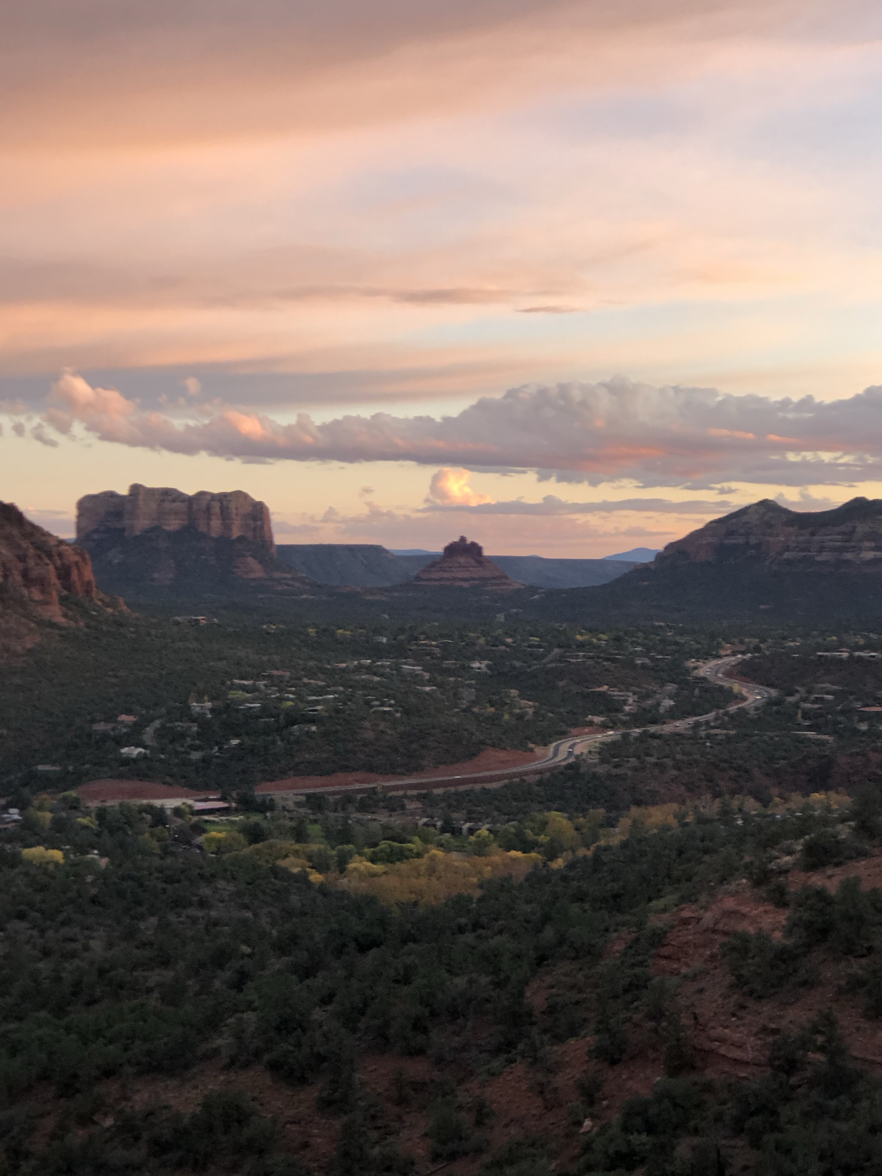
There is no other hike in Sedona that offers such awe-inspiring views as the Sedona Airport Mesa Loop Trail. It has 360-degree panorama with views of almost every major red-rock landmark along its perimeter.
The trail begins at the north end of the Airport Mesa, and is easy to find, due to good signage. The trailhead flows in a southeasterly direction as it follows the slope. There are outstanding red rock vistas from the northeast to the south, through the Oak Creek Valley. The trail is relatively flat for the first mile, and then gradually begins a gentle ascent as it heads south towards the end of the Mesa. Along this stretch of the trail, there are spectacular views of Elephant Rock, Courthouse Butte, Bell Rock, and Cathedral Rock.
As the trail meanders to the top of the south corner of the Mesa, it levels out and begins to head north, following the airport perimeter fence for about a quarter mile.
At about 2 miles into the hike, it intersects with the Bandit Trail that leads down into West Sedona. At this point, the Airport Mesa Loop Trail begins to descend for about a quarter mile, then gradually climbs in an eastward direction for the final stretch. This portion of the trail has a considerable amount of shade which makes hiking more comfortable during the warmer months of the year. To the west, Thunder Mountain (also known as Capitol Butte) looms as the highest of Sedona’s red rock peaks; it merges with Coffee Pot Rock, followed by the Soldier’s Pass wilderness, Wilson Mountain, Fin Rock, and Steamboat Rock. The trail ends at Airport Road, right across from the parking lot at the trailhead.
- Type of Trail: loop
- Total Milage: 3.5
- Total Elevation Gain: minimal
- Difficulty: Easy
- Fee: none unless you park up at the airport then $5 a day
BELL ROCK
The iconic Bell Rock formation is named after it’s unique “bell-like” shape, and is a great family friendly easy hike in Sedona. While there are many ways to enjoy this area (including hiking up the Bell Rock formation) most tend to hike along the Bell Rock Pathway Trail.

The Bell rock pathway trail links up the Bell Rock Vista Trail head to the Little Horse Trailhead for a total of about 3.6 miles (out and back style). Hiking this trail affords you amazing views of not only Bell Rock, but also Courthouse Butte and other notable landmarks in the area. The pathway trail is generally easy going and a flat trail, but there are some rocky areas and areas with hills. Hiking to the west side of Bell Rock will give you great views of the rock that you cannot get from the highway.
- Type of Trail: out-and-back
- Total Milage: 3.6 miles depending on trail taken
- Total Elevation Gain: minimal
- Difficulty: Easy
- Fee: $5 a day
DEVILS BRIDGE
If you are looking for a trail with epic views of Sedona, then you should put the Devil’s Bridge hike high on your must-hike list! According to USDA Forest Service it is the largest natural sandstone arch in the Sedona area. Your hike can start from one or two parking areas. If you have a higher clearance vehicle, you will be able to drive down Dry Creek Road (FR 152) to the trailhead which will make your total hike mileage around 2 miles roundtrip. However, if you are uncertain your car can make the clearance, opt to park at the Mescal Trailhead on Long Canyon Road and hike from Mescal to Chuckwagon to Devils Bridge for about 4 miles roundtrip.
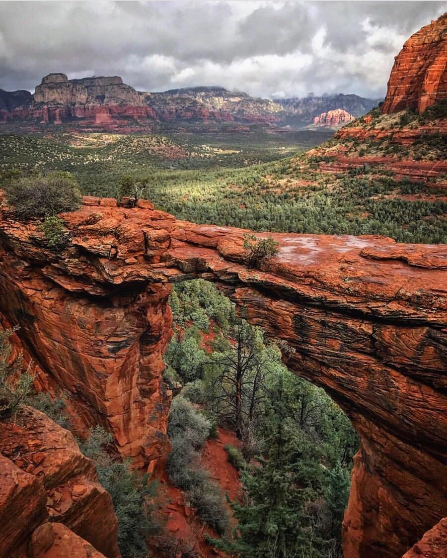
The trail is relatively easy to follow, and you’ll find the path starts out rather easy, but eventually you will start to gain a bit of uphill on your hike towards Devil’s Bridge. Follow the trail markers that point the way from the parking area. At about 3/4 of a mile from the parking area you will hit your first fork in the trail. Taking the left fork will lead you toward the base of the bridge, where you can look up and see the bridge standing tall above you. The right fork, however, will lead you up a natural rock staircase to the bridge itself, and if you’re brave enough you can even hike onto the top of the bridge. It’s a fairly wide bridge, but make sure to be careful and exercise caution because a fall here would be dangerous.
- Type of Trail: out-and-back
- Total Milage: 2 to 4 miles roundtrip (depending on where you start)
- Total Elevation Gain: 400 feet
- Difficulty: Moderate
- Fee: None
CATHEDRAL ROCK TRAIL
The Cathedral Rock trail is a steeper but short hike that is very popular in the Sedona area. Despite its steep climb though, you will be rewarded with excellent views all along the trail. Be prepared to not always be following a trail, many portions of this trail require using your best judgement to follow the path of least resistance toward the top. However, there are ample places to climb, and you can watch others if you are uncertain of the best path to take. This hike is more like a fun scramble than a hike really, but that is what makes it fun! Be prepared to use your hands and your feet to hike this one!
You’ll stay on the right path by following cairns from the trailhead and following the fairly obvious trail and staircases of steep rocks toward the top of the trail. Once the trail gets a bit rockier, there may be a point where you hesitate before deciding to continue on the steeper end of the trail. However, it is totally doable, just be smart and make use of the many hand and foot holds that lead toward the top of a “crevasse” feature. Please exercise caution at attempting this portion of the trail if it has recently rained. Continue onwards, scrambling up rock and climbing natural rock staircases as you make your way to the top, resting when you need to. When you get to the top you’ll see a sign that shows “End of the Trail” and that’s your queue to take in the beautiful views from the top! Return the same route you hiked to the top!
- Type of Trail: out-and-back
- Total Milage: ~1.5 miles roundtrip miles
- Total Elevation Gain: ~550 feet
- Difficulty: Moderate
- Fee: $5 a day
MERRY GO ROUND ROCK
Merry-go-round rock is the setting for some epic Sedona views and is often a coveted spot for couple’s engagement and wedding photos. There are 2 primary ways to access Merry-Go-Round Rock. One option is a 2 mile round trip trail via Schnebly Hill Road, but accessing this road can prove difficult and it is recommended that you have a 4WD high clearance off-road vehicle to get to the trailhead. The other option for hiking to Merry-Go-Rouond Rock is via Munds Wagon Trail which requires a bit longer of a hike, but is much more accessible to get to.
If you opt to hike the trail via Muds Wagon Trail, you will hike about 8 miles round trip and climb roughly 1,200 feet of total elevation gain. This main trail intersects a dirt road from time to time, and some find it easier to hike up the dirt road and back down via the trail. Even though there is roughly 1,200 feet of climbing involved, it ascends gradually on a well maintained and well marked trail and takes you by two popular rock formations. One of those formations is called Cow Pies and is a short distance off trail, and the other is the Merry-Go-Round Rock (aka Carousel Rock). When you get to Merry-Go-Round Rock you are afforded with amazing panoramic views of Bear Wallow Canyon and Munds Mountain.
- Type of Trail: out-and-back
- Total Milage: 8 miles
- Total Elevation Gain: ~1200 feet
- Difficulty: Moderate Sedona day hike (just long)
- Fee: none
